
Fail:Island of Ireland location map Cork.svg

Saiz pratonton PNG bagi fail SVG ini: 481 × 599 piksel . resolusi suai: 192 × 240 piksel | 385 × 480 piksel | 616 × 768 piksel | 822 × 1,024 piksel | 1,643 × 2,048 piksel | 1,450 × 1,807 piksel.
Fail sandad (Pail SVG, tipong tuou 1,450 × 1,807 piksol, ginayo pail: 642 KB)
| pongowowoyoon |
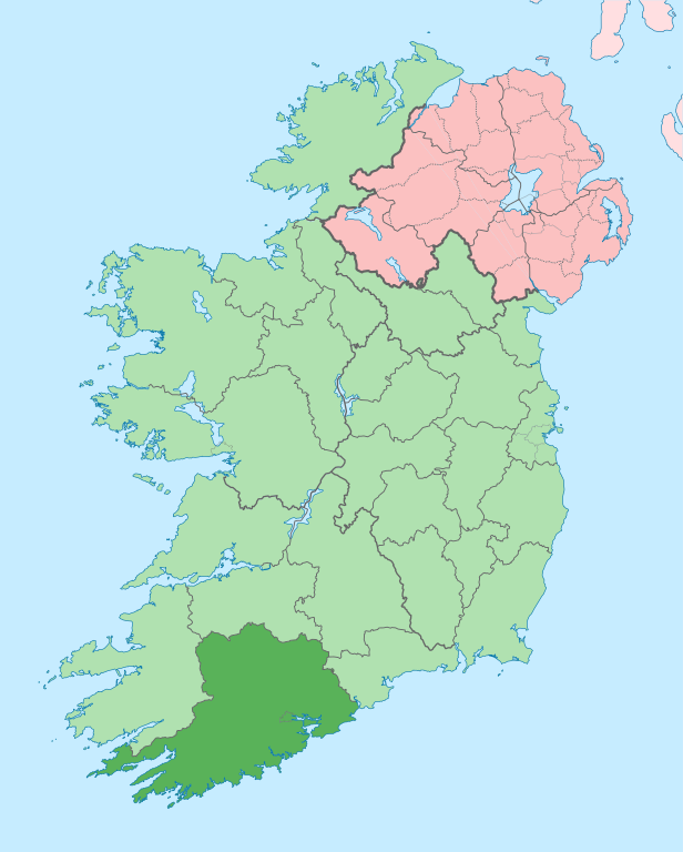
English: The island of Ireland, showing international border between Ireland and Northern Ireland, traditional provinces, traditional counties, and local authority areas in Ireland and Northern Ireland. |
| Tadau Wulan | (UTC) |
| kowonuan | |
| Sanganu |
|
| Ini adalah gambar sentuh, ini bermakna bahawa ia telah didigitalkan dari versi asal. Modifikasi: Coloured in regions with county of article highlighted. Versi asal boleh dilihat di sini: Island of Ireland location map.svg. Modifications made by Mabuska.
|
Dengan ini, saya selaku pemegang hak cipta karya ini, menerbitkannya di bawah lesen yang berikut:
Fail nopo diti nga id siriba lesen Creative Commons Attribution-Share Alike
3.0 Unported.
- Obibas ko:
- montok popoilang – montok mamadalin, popotikid om popoundaliu asil karaja
- montok popilongot – montok poposudong do kalaja
- Id siriba do syarat dilo:
- Pongokunan – Nuru ko do mongounsikou, manahak popioput kumaa lisin, om popokito sokiro haro kosimbanon di winonsoi. Milo ko do popowonsoi nunu nopo laang ii kosudong, nga' okon ko' id suang do nunu-nunu nopo laang di poposogu do minanahak lesen do monokodung diya toi ko' pomogunoon nu.
- poilango kopiagal – Sokiro nopo monimban, popirolot toi ko' momoruhang ko do kakamot, minog do pasarabakon o sakadai nu id siriba lesen same or compatible license miagal di intodon.
Log muat naik asal
This image is a derivative work of the following images:
- File:Island_of_Ireland_location_map.svg licensed with Cc-by-sa-3.0
- 2010-03-06T20:43:33Z Rannpháirtí anaithnid 1450x1807 (679207 Bytes) Fix incorrectly coloured isands.
- 2010-03-03T22:19:29Z Rannpháirtí anaithnid 1450x1807 (679744 Bytes) {{Information |Description={{de|Positionskarte von [[:de:Irland|Irland]]}} Quadratische Plattkarte, N-S-Streckung 170 %. Geographische Begrenzung der Karte: * N: 55.6° N * S: 51.2° N * W: 11.0° W * O: 5.0° W {{en|Location
Uploaded with derivativeFX
Sajara fail
Todoso id kalindo / maso do mongintong di upa dilo fail ontok di timpu nokomoi.
| Tadauwulan/Maso | Sinondulu | Ginayo | Moomomoguno | Komi | |
|---|---|---|---|---|---|
| timpu diti | 23:57, 26 Mahas 2020 | | 1,450 × 1,807 (642 KB) | Chipmunkdavis | Per the Local Government Reform Act 2014, joining both Tipperarys and both Waterfords (and removing Limerick City code). Colouring in islands, cleaning up and grouping code to remove stray objects and show Galway and Lough Ree. |
| 08:40, 19 Madas 2010 |  | 1,450 × 1,807 (821 KB) | Mabuska | {{Information |Description={{en|The island of Ireland, showing international border between Northern Ireland and Republic of Ireland, traditional provinces, traditional counties, and local authority areas in the Republic of Ireland and Northern Ireland.}} |
Pomogunaan do fail
Iti kiharo 2 bobolikon poingoput id pail diti:
Pomogunaan fail sompomogunan
Fail diti ginuna do wiki suai:
- Kopomogunaan id ang.wikipedia.org
- Kopomogunaan id ar.wikipedia.org
- Kopomogunaan id ast.wikipedia.org
- Kopomogunaan id be.wikipedia.org
- Kopomogunaan id bg.wikipedia.org
- Kopomogunaan id ca.wikipedia.org
- Comtat de Cork
- Cork
- Kinsale
- Cobh
- Riu Lee
- Plantilla:Comtat Cork
- Carrigaline
- Cúil Aodha
- Béal Átha an Ghaorthaidh
- Oileán Chléire
- Béal na Bláth
- Clonakilty
- Bandon (Cork)
- Bantry
- Fermoy
- Macroom
- Mallow (Cork)
- Midleton
- Passage West
- Skibbereen
- Youghal
- Baile Bhúirne
- Baile Mhic Íre
- Cill na Martra
- Castlelyons
- Clondrohid
- Castletownbere
- Rosscarbery
- Dunmanway
- Ballydehob
- Ringaskiddy
- Monkstown (Cork)
- Crosshaven
- Glanmire
- Glounthaune
- Carrigtwohill
- Blarney
- Ballincollig
- Ovens (Cork)
- Kilumney
- Ballinora
- Tower (Cork)
- Illa de Bere
- Illa Spike
- Castletownshend
Intangai lobi momomoguno sompomogunan do pail diti